
We have put together 4 proofs-of concept which demonstrate the ways we can now manipulate the Booth map and notebooks. We are now working towards testing of a prototype mobile application in the next few weeks.
Proofs-of-concept
There are four demonstrators:
- Booth map shown side-by-side, and …
- … overlaid transparently on a Google base map (other base maps will be available in the final version, including Open Street Map and Ordnance Survey)
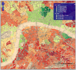
- Booth map overlaid with the Index of Multiple Deprivation 2010 (source: Department of Communities and Local Government, mapping by CASA/UCL)
- Booth map with notebooks entries available for reading, linked to the page level
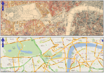


The side-by-side map and transparent overlay show the basic mapping functionality: retrieval of a location on the Booth map on the basis of a current location supplied by browsing a modern map (or vice versa).
The inclusion of the Index of Multiple Deprivation shows a government open data set being mashed up with the historical map (via some rendering by CASA/UCL: http://casa.oobrien.com/booth/) to facilitate comparison between the historic and contemporary geography of the space.
The rendering of the notebook entries shows the availability of eye-witness observations in the locality (which were the basis of the coloured, economic classifications of the streets).
The prototype
The proofs-of-concept demonstrate the ways in which the Booth data can be manipulated. Next, we need to be able to make that functionality available in a usable, mobile application.
Here is a screenshot of the current development version:

We have a development freeze scheduled for 18 June, which will be followed by some serious, in-depth testing in-the-field.

![]()