
We’re always interested to hear how you use the Statistical Accounts. Family historians are one of the key groups who make use of our service so we were delighted to see Jane Harris recently publish a blog on using the Statistical Accounts for family history research. Jane has kindly agreed that we republish her post – we hope it’s useful for those of you researching your Scottish roots!

Jane Harris
Jane specialises in Scottish genealogy and family history. A member of the Association of Professional Genealogists and the Scottish Genealogy Network, Jane provides both family history research and tutoring so you can do research yourself. Her particular interests include the Stirling area, where she lives, and Orkney, where she was born and grew up. Jane described her experience with the Statistical Accounts for us:
A row of books with rather dull dust jackets; a couple of interesting quotes in a lecture or course book. That sums up my knowledge of the Statistical Accounts from my student days. When I started seriously researching my own family history many years later that view changed rapidly. Checking the earlier censuses, I was fascinated by the number of distinctively Highland surnames in my father’s home parish of Walls, Orkney. The Old Statistical Account provided an explanation: that a large number of people had come from “Strathnaven”, having been cleared to make way for sheep, so early victims of the clearances. I was hooked.
The Statistical Accounts are now one of my standard sources for client research in the late eighteenth to mid nineteenth centuries, both for general background and also for specific information on churches, migration, occupations and so on.
Now for Jane’s original blog, with some great pointers…
S is for Statistical Accounts of Scotland
Keep reading! They are far more than numbers. The Statistical Accounts are two fascinating sets of reports on each Scottish parish in the 1790s and the 1830s/40s. They cover economic and social activities as well as natural resources.
What, when, who, how?
Sir John Sinclair of Ulbster sent out 171 queries to the ministers of each of the 938 parishes in Scotland in the 1790s. Their responses form the Old Statistical Account (OSA). In 1832, because of all the changes that had taken place in Scotland, a new survey was agreed. The responses are collectively known as the New Statistical Account (NSA). Find out more about the background.
How are the Statistical Accounts useful for family history?
- Context for our ancestors’ lives.
“The prejudices, entertained by the inhabitants of this parish, against inoculation [sic] were, for a long time, invincible. But the better sort, setting the example, the rest gradually followed… In one season 460 were inoculated, of whom only 3 died” (Kilmalie, Invernesshire, Old Statistical Account, p409). Mortality by age group statistics (Glasgow, Old Statistical Account p508).
- Information on churches other than the established Church of Scotland.
“There is in St Ninians a Relief meeting-house… there is another meeting-house in Ba-burn connected with the United Secession” (St Ninians, Stirlingshire, New Statistical Account p336).
- The state of the parish registers: “the fourth is a mere ragged fragment” (Wick, Caithness, New Statistical Account p137). May explain why you can’t find a baptism:
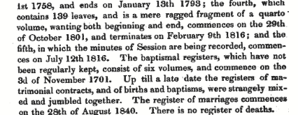
Excerpt from the New Statistical Account for Wick, Caithness, Vol XV, 1845, p137.
- Names of landowners, which could lead you to estate records.
For example, see Menteith, Perthshire, New Statistical Account p1108.
- Local history generally, development of industries, migration and so on.
“What accounts for this [population] increase of 71 is the settlement of a colony of Highlanders, who had been forced to emigrate from Strathnaven [sic], where their farms had been converted into sheep pasture” (Walls, Orkney, Old Statistical Account p313).
- The minister’s view on his parishioners.
This snip from the Dalziel, Lanarkshire, (Motherwell area) New Statistical Account is particularly rich:
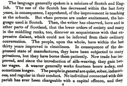
Excerpt from the New Statistical Account for Dalziel, Vol VI, 1845, p454.
In summary
Topography, geology, botany, agriculture, weather, population statistics, diseases, the state of the church and manse, manufactures, occupations (for example see table from Inverness’ Old Statistical Account below), wages, prisons, schools, language, history, antiquities, communications – and much more. Each account as individual as the minister who wrote it. You can find them all on the Statistical Accounts of Scotland website.
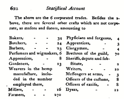
Table of occupations from the Old Statistical Account for Inverness, Vol IX, 1793, p622.
Thanks to Jane for letting us share her thoughts. You can find Jane’s blog here:
http://www.janealogy.co.uk/blog/
Follow Jane on Twitter @janenharris
Let us know your story
Could you share your Statistical Accounts experience with us? What have you found that’s been particularly helpful in your local or family history research? We’d love to hear from you. Comment below or email us, edina@ed.ac.uk.
![]()


