Create a linear buffer tool for Digimap for Schools

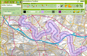
I’m working on the development of a new linear buffer tool for the Digimap for Schools service. Linear buffering is a common feature in GIS applications.

line-buffer-example

200 meters buffer on a part of river clyde in Glasgow

In geometrical terms such an operation on polygons is also known as Minkowski sum and offsetting.

I was looking of a Javascript library that would offer such functionality as OpenLayers2.13, currently used by Digimap for Schools, does not offer this as part of its codebase.

I came across 2 libraries that would offer this sort of functionality. One is JSTS andjsclipper the former being a port of the famous Java JTS Topology suite and the later being a port of the C++, C# and Delpi Clipper. I finally decided to go for jsclipper due to being unable to build a custom cut-down version of the huge JSTS library.

The resulting tool made use of jsclipper to calculate the buffer polygon along with OpenLayers, used to draw the buffer polygon and the inner linear path.

A standalone example along with the code, making use of EDINA’s OpenStream service, can be found here:  (Full screen here)

One of the challenges encountered was jaggy rounded ends on low buffer widths which is due to the way jsclipper handles floats. Fortunately jsclipper provides a method to scale up coordinates before passing them to jsclipper for offsetting and then scaling them down again before drawing. The Lighten and CleanPolygons functions also provided a way to remove unnecessary points and merge too-near points of the resulting buffer polygon.

All in all, jsclipper is a light, fast and robust library for polygon offsetting and would recommend having a look at it: https://sourceforge.net/p/jsclipper

Creating a transparent overlay map with mapbox-ios-sdk

For this blog post i have managed to capture on of EDINA’s mobile developers.  Their guest article will describe how to create transparent overlays for mobiles using mapbox-ios-sdk.

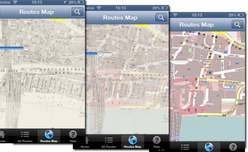
I am working on a historic map overlay, where the user can adjust the transparency of the historic map. The user can then see the how the land use has changed over time by using the slider.

opacity-map-overlay

I am going to use the map-box fork of route me. Looks like a good bug fixed version of Route-me and map-box do seem to have great some great products.

Unfortunately it doesn’t have an have an API to dynamically change the opacity of a tile source out the box. So I added it.

Its pretty easy to add. Each tileSource has a RMMapTileLayerView container when added to the map. Within that can manipulate the CALayer.opacity to get the desired effect.

I added a fork to github for testing

https://github.com/murrayk/mapbox-ios-sdk/

And example of use – the code is in github. Do a ‘git clone –recursive’ to install the submodules.

https://github.com/murrayk/mapbox-overlay-opacity-example

And example of use. In the  main view controller.

- (void)viewDidLoad
{
    [super viewDidLoad];
        // Do any additional setup after loading the view, typically from a nib.
    RMOpenStreetMapSource * openStreetMap = [[RMOpenStreetMapSource alloc] init];
    RMGenericMapSource * weatherMap = [[RMGenericMapSource alloc] initWithHost:@"tile.openweathermap.org/map/clouds" tileCacheKey:@"cloudCover" minZoom:0 maxZoom:18];

    self.mapView.tileSource = openStreetMap;

    [self.mapView addTileSource:weatherMap];

    self.overlay = weatherMap;
    // rough bb W = -30.0 degrees; E = 50.0 degrees; S = +35.0 degrees; N = +70.0 degrees
    NSLog(@"zooming to europe");
    CLLocationCoordinate2D northEastEurope = CLLocationCoordinate2DMake(70,-30);
    CLLocationCoordinate2D southWestEurope= CLLocationCoordinate2DMake(35,50);
    [self.mapView zoomWithLatitudeLongitudeBoundsSouthWest:southWestEurope northEast:northEastEurope animated:YES];

    [self.mapView setOpacity:0.5 forTileSource: self.overlay];

}

//hook up a slider to manipulate the opacity.  

- (IBAction)changeOverlayOpacity:(UISlider *)sender {

    NSLog(@"Slider value changed %f", sender.value );
    [self.mapView setOpacity:sender.value forTileSource: self.overlay];
}
If you found this blog useful, you might want to look through the archived articles on EDINA’s developers Geo-Mobile blog