Top 10 Christmas ideas for geo-geeks

It’s that time of year again.  Finding the perfect gift for those that we care about and trying to be just a little bit different or going that extra mile to get a gift that really will be cherished.  Increasingly, us map geeks have a host of carto related gifts that we can buy each other.  This post highlights some of them and will hopefully stand as a bit of inspiration for anyone who wants to treat a geo-geek who has been particularly good this year.

First off, you could do worse than looking at the list that i put together last year. Some of the links no longer map(sic) to the correct product, but some do.  Beyond that, the list below should give you some ideas of what i have stumbled across this year:

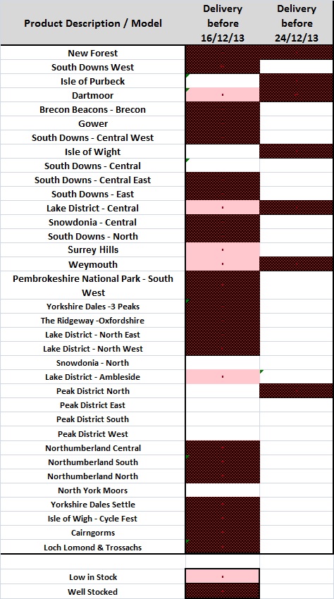
1. SplashMaps - SplashMaps are REAL outdoor maps designed for clarity and accuracy.  They are Washable, Wearable, All-Weather Fabric maps.  Prices are about £20 for a standard sheet and bit more for a custom Make-a-Map sheet.  Note that Make-a-Map maps cannot be delivered before Christmas.  Please choose the Map voucher for an even more personalised gift. There is a useful image showing the availability of standard maps that would be delivered by christmas.

splash

Splash Maps


2. Escape  maps– Available through many sellers on ebay are genuine WW2 escape maps. These tend to be printed on silk and were issued to service men, generally RAF, when they were on missions behind enemy lines. The maps were light and easy to hide in clothing but gave service men routes to escape back to allied territory.  I may have bought one last year and it is beautiful! Buy one and you will own a little piece of history. Prices vary, but around £25.

escape

A little bit of history

3. Jerrys Map – If you don’t know what Jerry’s map is, then please look at this video.  You can buy tiles from the map, these are copies of the original, but as the map is constantly evolving you actually end up with something that is unique. Again, i may have already bought some tiles and they are amazing.  If you happen to be in Edinburgh (perhaps over Hogmanay) then you can see the actual map which is on show at Summerhall.  Tiles are available through Ebay direct from the man himself. Prices vary, but start at less than £5.

JerrysMap

Jerry and the map

4. Bespoke map art– Yes, i know they featured last year, but they have expanded their range and there is something for every type of map geek. Prices range from 35 to over £50.

MapArt

Map Art – in this case a clock!

5. Cartographic T-shirt – stylish -shirts with subtle cartography on them. Nonfictiontees – £12, TFL Beck Tube map – £12, Polar projection goodness – £16,

tshirt

Map on a t-shirt

6. Animal World Map– This is a massive wall map of the World for kids.  Each country is represented by the animals that are associated with it. Although the UK seems not to get any animals, just Big Ben. Surely we could have has sheep, salmon, a Highland Coo or a Haggis! Prices are £21 for an A3 copy and £26 for an A2 copy.

animal

One for the kids

7. Typographic Maps– another “where art meets maps”, these typographic maps show several cities of the World (London, New York, Seattle…..) but features are represented just by their names.  The A1 posters cost £26.

Typo

Typo? What typo?

8. Map Bling– Jewellery with maps on it for him or her?  Sorted. Prices from £15-£50.

Bling

Bling

9. Wapenmap- A Wapenmap is a 3D contoured stainless steel metal map landscape sculpture. Cost is about £18

3D

3D Maps

10. A map – any map.  A true map geek will get a kick out of receiving a map.  The map could be new, old, antique, foreign.  It could link into a trip or anything.  I have received a Terry Wogan weekender map (dont ask), and it is great.  I have given people old maps of where they live and taken pleasure as they analyse how things have changed (Oxfam is a great place to get an old OS or Bartholwmews map)

That’s your lot.  What, no books i hear you say! Well i will put a list of some top map related books tomorrow.

Note – thanks to James Cheshire who blogged his wish list earlier in the month and i have blatantly stolen 1 or 2 ideas from it ;)

Geoforum 2013


Geoforum 2013

Geoforum 2013

EDINA had a day out in London running it’s Geoforum event. Geoforum aims to bring together Digimap Site reps from subscribing institutions around the country and showcase some of the new functionality in EDINA’s geoservices. It also gives site reps an opportunity to ask questions to the Digimap team and to chat with other reps about how information about, and support for, services is provided. There was a live blog running throughout the day which is well worth a read if you did not manage to attend the event. Links to videos and slideshare will be added as soon as they are available. The keynote speaker was delivered by Shelley Mosco of The University of Greenwich.  Shelley is a member of the The School of Architecture, Design and Constructionand  described the ways in which spatial data could be used to inform design. Shelly was keen to mention the importance of spatial data and GIS in the implementation of Building Information Models (BIMs).  BIMs have been used in large engineering projects for some time, however the government is making them mandatory for all publicly funded building projects in England and Wales. This means that commercial organisations will be looking for students to have been trained in the concept of BIMs and the software that drives them.  You can find out more about BIMs through the following links:

Geofurum 2013 keynote

Geofurum 2013 keynote

Shelley then handed over to two of her current MSc students who gave brief overviews of their experiences of learning about GIS and using spatial data in their projects.  Both David Parfitt and Rob Park were self-confessed GIS newbies, but they managed to get data from Digimap and use it in their conservation projects. The data allowed them to visualise and analyse the environment and provide evidence to support their proposed designs.  Their demo’s were excellent and really showed the power of simple GIS analysis.

You can view the slides from this presentation here:

Shelley_Geoforum

Digimap Data and a non-traditionalist approach – Shelley Mosco

Next up was a presentation that focused on Open Source Resources for Geospatial. The presentation looked at data, software and web-mapping. The main resources are listed below:

Data

  • OS Open data is available through the Digimap Data Download service.
  • ShareGeo Open is a repository for open geospatial data. It has lots of useful and interesting datasets on a variety of subjects such as wind farms, crime, boundaries and DTMs
  • Data.gov.uk – the uK government’s open data store

Software

  • QGIS – one of the best open source GIS out there. Lots of functionality and plugins that allow you to perform complex spatial analysis. It is also well supported by forums.
  • gvSIG – anther fully functioning GIS.
  • GRASS – a remote sensing package aimed at serious remote sensor’s. If you are a newbie to remote sensing, you can access GRASS tool through the GRASS plugin for QGIS which makes things really simple.

Web-mapping

Digimap is a great web mapping tool, but how can you create your own interactive web map for your website?

  • MapBox – simple intuitive web site that helps users build interactive web maps. Basic functionality is free, more advanced functions are available for a small fee.
  • Leaflet – the engine behind MapBox, it is free but requires user to do a “bit” of programing
  • Openlayers – an alternative to Leaflet which is more flexible. Openlayers powers Digimap. Requires a fair amount of programming knowledge.
  • MapServer – implements Openlayers for enterprise scale operations. MapServer is also used for Digimap services.
OpenSource

Open and “Free” Geo Software & Data – slideshare

Fieldtrip GB – data capture, simplified
Fieldtrip GB is a data capture app from EDINA. It simplifies the process of capturing data in the field against quality cartographic mapping. It is equally at home in urban environments as it is in rural ones. Custom forms allow users to design their own data capture projects and collect exactly what they need for their research.  The session gave a brief overview before running a “live” group data collection exercise.  A custom form was created and deployed to participants mobile phones. They then headed outside and captured data on things like building fabric and design.  After 15 mins everyone reconvened and the collected data was “synced” and exported to Google Earth.
You can view the slides from this presentation on slideshare:
FtGB Slideshare

FtGB Slideshare

FieldtripGB – data capture simplified from Addy Pope

As mentioned earlier, there is a transcript from a live blog (how on earth can anyone type so fast!!), so if you didn’t manage to attend and want to find out what happened please check it out.


Integrating Linked Data into the Carmicheal Watson Project

During the Linked Data Focus project we have been integrating Linked Data into a range of EDINA services. In this post software engineer Neil Mayo summarises how we have brought Linked Data to the 19th Century through our work on the Carmichael Watson project. But first a bit of background to this work…

Alexander Carmichael was a pioneering folklorist documenting the people, traditions, stories and culture of Gaelic-speaking Scotland. His most famous work focuses on the Hebrides, the famously beautiful but remote archipelago of islands off the west coast of Scotland. These are diverse environments and small communities whose equally diverse traditions and songs are captured in Carmichael’s Carmina Gedelica.

The Carmichael Watson Project website is an attempt to catalogue, digitise, transcribe and translate Alexander Carmichael’s notoriously eccentric hand written notes. The site creates new opportunities for scholars to understand his published work in the wider context of his lifelong research notes. However the role of place is so central to the notes and traditions recorded by Carmichael that being able to add further location information presented an excellent opportunity to further contextualise his work.  Linking the records of the cultures of people living in the Hebrides to a specific and modern sense of place – through maps and images – allows those investigating the texts to get a real sense of the relationship between songs, traditions and stories and the places that inspired or cultivated them.

Image of a Carmicheal Watson catalogue record showing linked data around places mentioned in the text (click through to access the record).

Image of a Carmicheal Watson catalogue record showing linked data around places mentioned in the text (click through to access the record).

So, how did we do that? Well on every catalogue page describing a catalogue entry, we incorporated linked data links for the place names, based on their longitude and latitude. There are links (where possible) to:

– Geo data and localised photos on Geograph
– Flickr photos within 2000m
– Location on Geonames map
– Map of nearby places on Geonames

An example can be seen at “A Toast” from Carmichaels 1883 notes:
http://www.carmichaelwatson.lib.ed.ac.uk/cwatson/en/catalogueentry/2652

and a rather over the top one (listing all the places in a single notebook) in item Coll-97/CW89 from 1887:
http://www.carmichaelwatson.lib.ed.ac.uk/cwatson/en/catalogueentry/3764

Additionally, on the A-Z listing of places, we have embedded linked data in the HTML, using ontologies from:

– Ordnance Survey: http://data.ordnancesurvey.co.uk/ontology/spatialrelations
– GeoRSS: http://www.georss.org/georss
– W3C Basic Geo: http://www.w3.org/2003/01/geo/wgs84_pos#
– SKOS: http://www.w3.org/2004/02/skos/core
– FOAF: http://xmlns.com/foaf/0.1

You can see the linked data in this page, for each level of each place (separated by a pipe |):
http://www.carmichaelwatson.lib.ed.ac.uk/cwatson/en/azindex/places

We would love to hear your thoughts on this use of Linked Data – please just leave us a comment below. And if you have any questions or comments on the Carmichael Watson Project itself then please do contact the team at: carmichael.watson@ed.ac.uk.

Tagger – Final Blog Post

As part of the UK vision for supporting open discovery principles in relation to education materials, JISC has sponsored a number of projects to assist in discovering and enriching existing resources.Tagger (variously referred to previously as GTR or geotagger), was one strand of the JISC funded umbrella DiscoverEDINA project. For the two other strands to this work see here.

The primary purpose of Tagger is to assist in enriching and exposing ‘hidden’ metadata within resources – primarily images and multimedia files. Images for example embed a lot of descriptive and technical metadata within the file itself and very often it is not obvious that the main focus of interest – the image, is carrying a ‘secret’ payload of information some of which may be potentially compromising. For example, the recent embarrassment suffered by Dell after a family member uploaded images to social media sites with embedded location information, thus frustrating the efforts of a multi-million pound security operation. Or take the case of the US military when an innocently uploaded photograph of a new assignment of Apache helicopters led to their destruction when insurgents used the location information embedded in the image to precisely locate and destroy the helicopters.

There are many other instances of people being innocently or naively caught out by these ‘hidden’ signposts in resources that they distribute or curate. Tagger helps by providing tools to expose those hidden features and makes it easy to review, edit and manage the intrinsic metadata routinely bundled in resources. It has concentrated on, but not been limited to, geotags.

Tagger has delivered three main things:

  • A basic web service API based around ExifTool, suitable for 3rd party use to geo-tag/geo-code image, audio, and video metadata.
  • A demo web site enabling user upload, metadata parsing (from resource) and metadata enrichment (map based geo-tagging/geo-coding);
  • An Open Metadata corpus of geo-tagged/geo-coded enriched records with a REST based query interface. Currently, this corpus consists of approximately a quarter of a million creative commons licensed geotagged images mainly bootstrapped from Geograph.

Tagger supports the open discovery metadata principles and has made extensive use of open licensing models.

Along the way we started thinking about specific use cases. The ‘anonymise my location’ seemed an obvious case and Tagger’s API and website reflect that thinking. Additionally, in talking to colleagues involved in field trips it was clear that there was potential in providing integrated tooling and we experimented with Dropbox integration.

Taking this further and building on EDINA’s more general mobile development work, we then started to think about how Tagger could be used to assist and enrich in-field data capture use cases and post-trip reflective learning. We continue to explore this beyond the project funding as the enrichment facilities Tagger provides allows for flexible integration into 3rd party services and projects.

Of course, Tagger will never be a complete panacea for all the ills of metadata nor should it aim to be. However by building on best-of-breed opensource tools (Exiftool) Tagger, or more accurately the Tagger API, provides a facility for other service providers and projects to make use of to enable better manipulation and management of those ‘hidden’ metadata.

Therein lies the rub – the perennial  question of embedding and take up.

That’s are next challenge.

Multimedia tagger

After a little hiatus caused by the vacation season we are happy to announce a few updates:

  1. we have a little demo site that allows users to upload their images and to expose/view/edit the embedded metadata. You can update any writeable metadata tags back into he image or export is as a sidecar XMP file. The website also exposes previously uploaded images and these can be browsed on the map by right clicking and choosing ‘Nearby Images’.  We’ve also been experimenting with Dropbox integration allowing users to save their images into their own Dropbox accounts. This is still rough around the edges but flags up the direction of travel. As always, we are happy to receive feedback..
  2. the website is ultimately powered by a backend web service. The API for that is now at version 1 and includes the new Dropbox methods.

Our primary goal with 1. above has been to showcase the middleware API of 2. show its not intended to be a GeoFlickr competitor, rather an illustration of what you can do using the API. Our Dropbox thinking has been influenced by talking to people in the community who run field work courses where often students need to take photographs of things in the field and then have access to them at  a later stage for annotation or reflective study.

One last change of note. The name. We have now settled for the more generic name ‘Tagger’. Its taken a while (the full project!!) but I think we are all mostly happy with the choice – its not too explicitly ‘geo’ and yet it remains descriptive of capabilities.

Posted in Geo

Geofences

Flickr have fairly recently introduced what they call ‘geofences’ which allow users to set privacy options on location information for selected images. Ostensibly this looks like a case of ‘job done’ but on closer investigation it actually reinforces our previous post about having  an explicit purge/delete capability – a sort of ‘un-geotag’.

This article provides a good overview of why this might be needed. Alternatively, if you actually want to spy on friends and colleagues take a look at this Creepy little app…


Posted in Geo

The perils of geotagging and why we have a Purge Use Case

One of the use cases we have come up for GeoTaggingResources (GTR) is for a facility to purge or delete intrinsic geospatial metadata embedded within (typically) an image.

Why, you might ask, given the pains that people go to to geotag images in  the first place, would I want to get rid of that information?

Well, this article and this piece clearly highlight the perils of indiscriminate and ‘silent geotagging’…


Rob Me

Rob Me


Share

Posted in Geo

API draft

We now have a first draft on the API and are keen to have feedback on its utility.

We also have a constantly evolving demonstrator illustrating metadata parsing, editing and enrichment. We know we have stuff to do and coming shortly will be access to an open corpus of geo imagery metadata..


Share

Posted in Geo