
Hi, We are running a webinar for any of you who are new to Digimap Collections, on 17th February at 11am GMT. We will introduce the key features of our Digimap mapper, Roam and consider when you would use Data Download. You will have the chance to ask questions. By the end of the webinar […]
Author Archives: Vivienne Mayo
Got 10 minutes?
We’ve put together a series of 4 short guides on using Digimap for Schools. The guides are intended to be worked through over 4 weeks and new subscribers to the service will be sent one each week, post sign-up. Each guide takes just 10 minutes and by week 4, you’ll be making the most of the cross-curricular potential that Digimap for Schools offers.
We guide you sequentially through key features and provide short videos to demonstrate each function. A short practise exercise plus links to some of our lesson ideas are included.
Have a look and let us know what you think!
- Week 1 Maps and Places Get to grips with the essentials of searching, zooming and viewing our range of maps – contemporary, historic and aerial.
- Week 2 Making your mark Find out how to add text, shapes, symbols and images to your maps. Create prints in different sizes and formats. Organise your maps into folders for different classes or projects.
- Week 3 The numbers Check out how to find a grid reference and measure map features. Add measurement labels to any shapes and lines you create.
- Week 4 Explore and Report Explore the Geograph images available at your location. Add buffer zones. Create and upload a file of points to your maps.

Week 3 – add measurement labels.
Lesson ideas
Remember we have lots of resources, written by curriculum experts, with great ideas for using Digimap for Schools. Browse by subject and level at our resources site:
https://dfsresources.edina.ac.uk/
Keep in touch
We really value your feedback so let us know if we can improve these, or if there are any other resources that we can provide to help you get mapping!
Ask us anything!
Digimap have scheduled two “open surgery” webinars, open to all Digimap users. These hour long sessions offer the opportunity for you to ask any questions you may have about Digimap. Our team have a wealth of experience of mapping data and can help you with: using the service – how to get the map or data you […]
Learning resources redesign
Have you checked out our free resources recently? We’ve updated this area of our website to make it easier for you to see what’s available. We have lots of high quality resources for each stage of the curriculum, written by geography experts such as Dr Paula Owens and Alan Parkinson. Have a look and get some fresh ideas for the new term!
You can now browse and filter all of our resources by subject. We’ve added a subject page for all of the major curriculum areas – you can see some examples on this image of the starting screen:

Starting screen
After selecting a subject, you can browse the available resources – each has a short description to help you decide which are most useful to you:

Browsing resources
You also have the option to open a Filter Results panel, which allows you to select multiple stages and subjects – so for example you could look at Geography resources for Stage 2 and Stage 3, or Outdoor Learning resources for Primary levels:

Filter by stage
For those who like to keep their options open, we’ve included a Primary and Secondary page so that you can browse and filter all resources available for those stages.
Your feedback
We think this is going to make life much easier for you. As always, it would be great to get your feedback. Does the new design work for you? Have you put any of the reources into practice? Get in touch and let us know!
https://www.facebook.com/digimap4schools/
Family history and the Statistical Accounts
We’re always interested to hear how you use the Statistical Accounts. Family historians are one of the key groups who make use of our service so we were delighted to see Jane Harris recently publish a blog on using the Statistical Accounts for family history research. Jane has kindly agreed that we republish her post – we hope it’s useful for those of you researching your Scottish roots!

Jane Harris
Jane specialises in Scottish genealogy and family history. A member of the Association of Professional Genealogists and the Scottish Genealogy Network, Jane provides both family history research and tutoring so you can do research yourself. Her particular interests include the Stirling area, where she lives, and Orkney, where she was born and grew up. Jane described her experience with the Statistical Accounts for us:
A row of books with rather dull dust jackets; a couple of interesting quotes in a lecture or course book. That sums up my knowledge of the Statistical Accounts from my student days. When I started seriously researching my own family history many years later that view changed rapidly. Checking the earlier censuses, I was fascinated by the number of distinctively Highland surnames in my father’s home parish of Walls, Orkney. The Old Statistical Account provided an explanation: that a large number of people had come from “Strathnaven”, having been cleared to make way for sheep, so early victims of the clearances. I was hooked.
The Statistical Accounts are now one of my standard sources for client research in the late eighteenth to mid nineteenth centuries, both for general background and also for specific information on churches, migration, occupations and so on.
Now for Jane’s original blog, with some great pointers…
S is for Statistical Accounts of Scotland
Keep reading! They are far more than numbers. The Statistical Accounts are two fascinating sets of reports on each Scottish parish in the 1790s and the 1830s/40s. They cover economic and social activities as well as natural resources.
What, when, who, how?
Sir John Sinclair of Ulbster sent out 171 queries to the ministers of each of the 938 parishes in Scotland in the 1790s. Their responses form the Old Statistical Account (OSA). In 1832, because of all the changes that had taken place in Scotland, a new survey was agreed. The responses are collectively known as the New Statistical Account (NSA). Find out more about the background.
How are the Statistical Accounts useful for family history?
- Context for our ancestors’ lives.
“The prejudices, entertained by the inhabitants of this parish, against inoculation [sic] were, for a long time, invincible. But the better sort, setting the example, the rest gradually followed… In one season 460 were inoculated, of whom only 3 died” (Kilmalie, Invernesshire, Old Statistical Account, p409). Mortality by age group statistics (Glasgow, Old Statistical Account p508).
- Information on churches other than the established Church of Scotland.
“There is in St Ninians a Relief meeting-house… there is another meeting-house in Ba-burn connected with the United Secession” (St Ninians, Stirlingshire, New Statistical Account p336).
- The state of the parish registers: “the fourth is a mere ragged fragment” (Wick, Caithness, New Statistical Account p137). May explain why you can’t find a baptism:
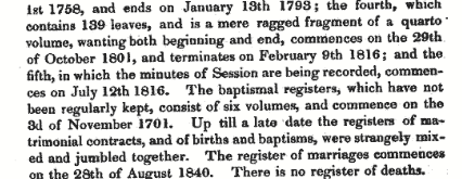
Excerpt from the New Statistical Account for Wick, Caithness, Vol XV, 1845, p137.
- Names of landowners, which could lead you to estate records.
For example, see Menteith, Perthshire, New Statistical Account p1108.
- Local history generally, development of industries, migration and so on.
“What accounts for this [population] increase of 71 is the settlement of a colony of Highlanders, who had been forced to emigrate from Strathnaven [sic], where their farms had been converted into sheep pasture” (Walls, Orkney, Old Statistical Account p313).
- The minister’s view on his parishioners.
This snip from the Dalziel, Lanarkshire, (Motherwell area) New Statistical Account is particularly rich:
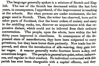
Excerpt from the New Statistical Account for Dalziel, Vol VI, 1845, p454.
In summary
Topography, geology, botany, agriculture, weather, population statistics, diseases, the state of the church and manse, manufactures, occupations (for example see table from Inverness’ Old Statistical Account below), wages, prisons, schools, language, history, antiquities, communications – and much more. Each account as individual as the minister who wrote it. You can find them all on the Statistical Accounts of Scotland website.
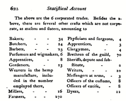
Table of occupations from the Old Statistical Account for Inverness, Vol IX, 1793, p622.
Thanks to Jane for letting us share her thoughts. You can find Jane’s blog here:
http://www.janealogy.co.uk/blog/
Follow Jane on Twitter @janenharris
Let us know your story
Could you share your Statistical Accounts experience with us? What have you found that’s been particularly helpful in your local or family history research? We’d love to hear from you. Comment below or email us, edina@ed.ac.uk.
![]()
Digimapping your Daily Mile!
We are delighted to present new learning resources that give you some great ideas for bringing your Daily Mile into the classroom. As well offering a simple way to build physical activity into your pupils’ day and clear benefits to physical and emotional health, your Daily Mile offers a hook for building your pupils’ numeracy and research skills.
The Daily Mile initiative was officially launched in 2016 to encourage all schools to get outside and walk or run for 15 minutes a day. The idea began in 2012 when Elaine Wyllie, head of a Scottish primary school, was shocked that a class of pupils struggled to run a lap of their playing field. The children and teachers decided to start running around the field for 15 minutes a day to see if they could get better at it. Within 3 months, every class in the school was doing their Daily Mile and the children loved the freedom of running, jogging, skipping or walking with their friends in all weather. Hundreds of schools have picked it up and it’s spreading to Europe and North America too!
How can Digimap for Schools help?
Have a look at our Daily Mile resource section for ideas. A few suggestions to get started:

Measuring your Daily Mile!
- Plot your route and check the distance with the line drawing and measurement tool
- Explore your area using a 1-mile buffer – where could children reach by running a mile in different directions? Extend this exercise by looking at aerial and historic maps of your area.
- Choose a famous route, such as Harian’s Wall or the West Highland Way. Find out the distance and calculate how many Daily Miles it would take your class to complete the route!
- Add Geograph photos to your maps to see what geographic features have been photographed in your area or find photos of famous landmarks.
- Research and plot a route, with distance and stopping points, to show tourists around your town.
We hope you enjoy exploring the resources and bringing your Daily Mile into the classroom! Remember, we would love to see photos of the maps you create or of you out and about on your Daily Mile – tweet them to us @digimap4schools.
Managing your saved maps
We have recently added the ability to create sub-folders within your Digimap for Schools account, to help you store and organise your saved maps. You could create folders for different classes, projects, dates, places or schemes such as Duke of Edinburgh.
To get started, click on the Map Manager icon on the toolbar:

Map Manager icon
You will need your PIN to continue. These have been emailed to the main Digimap for Schools contact at your school. Check with them for the number or contact us to request it.
The Map Manager area will open and you will see a list of saved maps. It’s a good idea to create folders first. Click Add Folder on the left and name your folder. When you next create and save a map, you can select any of your folders to save the map within.
You can make the list of saved maps more manageable by filtering. Just enter your term(s) in the four boxes at the top of the list and your list will reduce. In the image below, we have input 7 in the Class box and sam in the name box:

Filtering saved maps
To move maps to any folder, just click a map and drag it to the folder of your choice. You can move multiple maps by checking the boxes to the right of the maps and dragging all of the selected maps to a folder.
We’ve made a short video on this feature:
Click here to view the embedded video.
We hope it will be a really useful tool for you. Let us know how you find it and if there is anything we can do to improve it.
An endorsement
We recently received some fantastic feedback on Digimap for Schools from Dr Neil Clifton, a retired chemistry teacher/lecturer in his eighties. When his grandson showed him the service, Neil was so impressed he sent us an endorsement. A lifelong mapping and geography enthusiast, whose son studied geography, Neil enjoys contributing photos to the Geograph project.
We particularly like Neil’s point about the maps helping young people to develop a love for their environment and wanted to share his considered thoughts with you:
Every child/pupil/student in every school in Britain should have access to this brilliant facility which has been developed by a team at Edinburgh University in co-operation with Ordnance Survey.
For little more than the cost of a set of text-books, the project allows access to the whole range of Ordnance Survey mapping, right up to the largest scale of 1:1250, (on which even garages, sheds and tiny streams are depicted, and where appropriate, named).
The team has put much thought into the project, which has made it easy to use, and attractive in appearance, so that even young children will enjoy exploring and using it, for locations such as their immediate home surroundings, as well as for locations that they have visited, or hope to visit, in more distant parts of Britain.
A beginner, in perhaps year 1 or 2 in their junior school, might look at a map showing their own school. And as the child develops and matures, they will trace their own house and the route they follow to get to school. Then, finding perhaps the location of the local supermarket, where the railway station is situated and so on, their confidence as map-users will increase all the time. The pond or stream where they go fishing will be found – and perhaps the map will enable the discovery of other possible fishing sites nearby.
The benefits to those students taking geography examinations can hardly be overstressed. But there are so many other ways in which the use of these maps will help the young person to acquire a love of the environment and a care for its well-being.  It is here that our future botanists, naturalists, photographers, walkers, cyclists, and leaders of the next generation of young people are born.
If any teacher is still unconvinced of the real and lasting value of making this resource available in their schools, I would urge them to look at the (free) trial which shows just a small area of the country.
Dr Neil Clifton, April 2017
Geograph images now available!

Geograph images as viewed in Digimap for Schools
You can now view images from the Geograph project in Digimap for Schools. Geograph aims to collect images for every grid square in Great Britain. So far more than 5 million images have been contributed.
Just click the Geograph icon on the toolbar to start searching and viewing images. Our search facility offers suggestions as you type to aid your explorations. A short help video is available on  YouTube, to help you get started.
Dr Paula Owens has authored some fantastic new learning resources to accompany the new Geograph feature.  They have lots of ideas to inspire you to use the images. Landscape Alphabet has some fun ideas on using the images in Key Stage 1 to support language development. There are three resources aimed at Key Stage 2; A focus on rivers, Flooding and Other Hazards, and Photographic! There’s also a Getting Started resource with lots of suggestions for searching. All resources include ideas for linking in literacy and numeracy.
We hope you will find Geograph a useful tool and enjoy viewing the wonderful images that are available. Do send us your feedback and any examples of fun images you find!
Upcoming webinars
Hi folks, we have planned a series of webinars in April and May.
Webinars are free to attend. They are open to all schools subscribed to Digimap for Schools  and anyone interested in learning more about the service. To join a webinar, you must register to book your place.
To see more details on the webinar content and register, click the link after the webinar of interest to you.
Hope to see you there!
- Tuesday, April 25th, 4:15pm to 4:45pm. Getting Started with Digimap for Schools
- Wednesday, April 26th, 4:15pm to 4:45pm. Getting Started with Digimap for Schools (Ofsted 3&4 Schools)
- Tuesday, May 2nd, 4:15pm to 4:45pm. Using Annotations and Creating Land Use maps in Digimap for Schools
- Wednesday, May 10th, 4:15pm to 4:45pm. Using Digimap for Schools for Fieldwork
- Tuesday, May 16th, 4:15pm to 4:45pm. Ideas for primary teaching with Digmap for Schools
If you have any questions about attending a webinar, or would like to suggest topics for future webinars, please comment below or get in touch with the Digimap for Schools Helpdesk – digimap.schools@ed.ac.uk